Tuesday, June 29, 2010

Up Early

What do you do when you wake up at 5:15 in the morning and see this?

You get up to enjoy it!


Monday, June 28, 2010

Another Trip to the Past


Our campground has a mailing address of Garryowen, Montana, however the "town" consists of a gas station/convenience store and the Custer Battlefield Museum.  The name of the town comes from the marching song used by the 7th cavalry of George Custer.  Originally this was simply a small way station for trains to pick up water and drop of mail and supplies to area forts and homesteaders, but the land was included as part of the Crow Reservation when that was created.  Later the Crows sold some of the land to private citizens but still all that was there was the small store.  At the time of the 50th anniversary of the battle of the Little Bighorn, workmen were excavating an irrigation ditch when they uncovered a partial skeleton surrounded with buttons and bullets which indicated that the man had been a cavalry soldier.  Assumed to be one of the 14 men of Reno's troops who was never accounted for, the remains were reburied in a special monument created to the unknown soldier and concluded with a "burying of the hatchet" ceremony which included burying a hatchet with the soldier after a peace pipe had been smoked.

The museum itself has a very nice display of photographs of American Indians, many of whom were involved in the battle with Custer.  There are also Native American artifacts, some bullets taken from areas of the battlefield and information on the battle of Little Bighorn, including a 45 minute documentary film which was extremely interesting and also made you rethink what you learned about the battle in school.  That alone was worth the small price of entry.

Between exploring the battlefield area and working on the trailer (putting the repaired leaded glass window back in the door, trying to modify the poorly functioning air conditioning system, defrosting the fridge, etc.) and just sitting outside enjoying the scenery and watching the world go by, the week has passed quickly.  It's time to move on, this time to a tiny town called White Sulphur Springs.  We'll find someone to remove the stitches from Denny's neck, play a round of golf and see what trouble we can find to get into.

Happy Trails!

Friday, June 25, 2010

Ambivalent About Little Big Horn

I'm not going to retell the story about the Battle at Little Big Horn.  It's in all the history books and there is a ton of information online.  What I will tell you is that the National Park service has done a fine job here of  providing information to help you understand what occurred here on the ridges and plains of the Crow Reservation.  There is an audio CD available for purchase, there are a few locations where you can make a call on your cell phone to hear pre-recorded information about the site where you are standing, there are bus tours led by Native American tour guides to take you on the five mile journey to the Reno-Benteen Battlefield where the first skirmish of the Battle of Little Bighorn began, Park Rangers (some of whom are Native Americasn) lead informational walk/talks close to the visitor center or you can simply drive the route, stopping to read the informational plaques placed by the roadside and following paved walking paths.  You are asked not to wander upon the grounds, not only in respect for the grave sites but because there are rattlesnakes in the thick grasses.  The grounds of the park are as they were on that fatal day of July 25, 1876--when you look to the ridge five miles away where Reno and Benteen waited with their troops, you see it as Custer saw it.  Back then the air was filled with dust, gun smoke and screams; today it is eerily quiet.

I have looked forward for a long time to visiting the battle site, but once I was here I was saddened at the suicidal mission of Lt. Col. George Custer and his men.  As the park ranger who spoke at the visitor center said, Custer was a hero during the Civil War which ultimately led to the end of slavery but then he was given the task of forcing the Native Americans back to their reservations and thus into a form of slavery.  Ironic indeed.


In 2003 the park service dedicated this memorial to the Native Americans who fought on both sides of the battle in an effort to be fair to the Native American perspective.  Inside there are panels reflecting statements from several tribe members, creating a circle.  On the grounds of the battlefield are red granite markers which show the location of fallen warriors, a practice started only in 1999, once again in an attempt of fairness to the history of the site and the people involved.


I'm glad I came, but what we as a nation did to the Native Americans saddens me.  This battlefield is just as much the Native Americans' last stand as it was Custer's.

Tuesday, June 22, 2010

Another New Road

Yesterday's trip from Cody to Garryowen, Montana was another new route for us.  This time we took US 14-16 which is the Bighorn Scenic Byway and Wyoming doesn't exaggerate its claims one bit.  Abandoned airplanes, red rock, tan rock, white white streams, overflowing rivers, the Big Horn mountains and roads that tried to twist back around on themselves which is not necessarily a fun thing when your twenty-some foot long truck is pulling a 38 foot trailer through said mountains.  But gorgeous it was and we even spotted a moose cow on the far side of Shell Canyon before we crested Granite Peak at 9034 feet, which was a climb of 5000 feet for us.  Quite a drive indeed.

Friends Don and Vicki were waiting patiently at the campground for us; they had held over an extra day so we could meet up for one day and catch up on their Alaska cruise.  Denny and I lost a few hours of time with them because our morning started with Denny having to have a Moh's procedure done to remove some basal cell carcinoma so we left Cody about three hours later than we normally would plus those steep, twisty mountain roads slowed us down quite a bit.  But the four of us made the most of what time we had, yakking, enjoying Don's delicious homemade chicken enchiladas and swilling homemade Lynchburg Lemonade.  Good times!
Don and Vicki are heading east to get to Ohio in time for our 40th high school reunion while Denny and I are still working our way north and west before we need to be in Seattle for our own Alaska cruise near the end of August.  The four of us will meet up again in Myrtle Beach, South Carolina in the fall for a month of talk, golf, games, Happy Hour bar hopping, beach walking, shark teeth searching good times.

In no particular order, leaving Cody, Wyoming, heading east on US 14 through the Big Horn mountains to Interstate 90 up to Garryowen, Montana.

Foothills.

Denny and I thought this was an airplane graveyard.  It turns out it is the Museum of Flight and Aerial Firefighting.  Kinda.

Driving through the Shell Canyon portion of the trip. There is a waterfall in the canyon, but the parking lot was too crowded for our rig, plus we had miles to go and promises to keep.

More of the canyon.

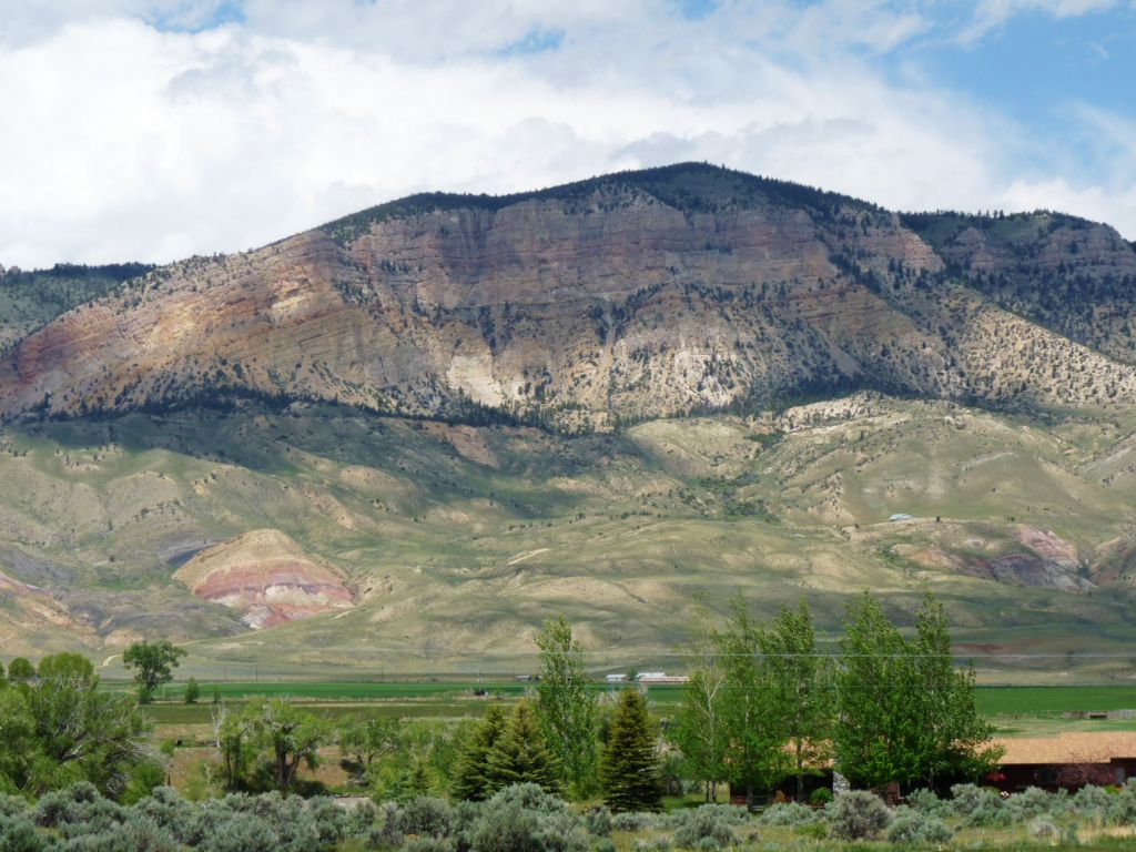
Every curve in the roadway led to a new palette of colors.


The state of Wyoming does something I think is interesting--they label the various rock formations with the era that it was created along with the tentative dates.  I did not take any pictures of any of the signs though.

We had been coming down off the mountains for quite some time before I took this photo since it was so hazy in the distance.  We were WAY up there!


After we were all set up and settled in with an adult beverage and chatting with our friends Don and Vicki we were subjected to a brief thunderstorm.  When that cleared up we ate dinner outside and then had a nice (not spectacular, but nice) sunset to enjoy.

The clouds above us were pretty neat, though.  Vicki and I checked for stars later, but the clouds were still thick in the sky.  I would imagine I'll be able to see a lot of them if the clouds clear up this week.
I would say our route is a good one for a day trip as there were a lot of picnic areas and small visitor centers (and that waterfall!) and places to pull over and just enjoy the scenery.  The pictures don't begin to do the area justice.

Sunday, June 20, 2010

Buffalo Bill Historical Center

For $28 we spent two days and wandered through five different museums, all in the same building.  The Buffalo Bill Historical Center consists of the Plains Indian People museum, the Western Art center, the Firearms musuem, the Buffalo Bill and the American West museum and the Nature of Yellowstone museum.  In addition, there are outdoor gardens with sculptures, but true to our luck, because of the monster winds we had this week the gardens were closed due to downed and "loose" trees per one of the staff members.  I swear, this year we are bringing weather weirdness wherever we wander (and say THAT five times fast!)

If you love Remington, Russell, cowboys, Native Americans, history and the West, this is the place to come for some serious culture immersion.  The artwork here is phenomenal and there was a special exhibit this week called "Splendid Heritage: Perspectives on American Indian Art" along with an exhibit of Gertrude Kasebier's photographs of Buffalo Bill's Wild West Warriors that wonderfully expressed the pride and dignity of the Native Americans who were part of Buffalo Bill's show.  

I could go on and on about the historical center because the exhibits are wonderfully showcased, well researched and thoughtfully laid out.  I have to admit, Denny and I passed on the firearms museum which appears to be huge, because guns don't interest us to the extent of spending an hour or so looking at them.  That section also appeared to have the rifles and pistols very artfully displayed and of course a lot of people headed that way.  This weekend the town of Cody also hosted the Winchester Gun Show, as well as a Powwow and a bead show, so there's no end of places to go and things to see in this town.  And we didn't even wander the town of Cody with its little bars, jewelry, boot, clothing and cowboy stores, along with restaurants, rafting trip shops and other places to explore since we have no room for souvenirs and the nifty stuff I'm sure I would have found (hey, I can always find a piece of jewelry I admire!).

Here are a few pictures, starting with me and Buffalo Bill himself. 


A display of Native American headdresses.

This bronze by Remington called "Coming Through the Rye" fascinated me due to the fact that the first horse has NO feet on the ground.  Remington pushed the envelope at having as few of the horses feet on the ground and still have a balanced piece of sculpture. Clicking on the picture will enlarge it.

Plains Indians would create an artifical curbing with large stones leading to the edge a cliff and then chase a herd of bison towards the cliff.  The first bison would see the edge and attempt to turn back but the force of the bison racing forward would push them over the edge en masse.  It was the Indians way of harvesting a large number of bison at one time and this sculpture captures that event.


Called the Redick saddle after its designer, this saddle has 100 ounces of silver inlaid in it and weighs about 105 pounds.

A Plains Indian beaded saddle.  Big difference from the one pictured above, huh?


Native American bead work on bandolier bags.

A more modern interpretation of cowboys entitled "Lookin' for the Whajamajigger".


The  Nature of Yellowstone section has a lot of great information about wildlife that is native to the area with well-mounted examples of birds and mammals on display in simulated "natural" settings.  It is very kid-friendly with hands on activities, many recordings of animal, reptile and bird sounds and imparts a lot of information in a way that isn't preachy-teachy.  And yes, I know that's not a word, but you get the idea. But the displays are for adults also and again, the staff has done a great job at displaying and effectively getting the information across to its audience.

The RV Vagabonds definitely gives the Buffalo Bill Historical Center a big two thumbs up.

Older RVers

Just because you're old, doesn't mean you're a geezer! This belongs to a neighbor here in our campground. Pretty snazzy, huh? He has ground effects (special lights that glow on the bike at night) too.

Me likey!

Saturday, June 19, 2010

Cold at the Rodeo

Because the sun had come out and the 50 mph winds had died down, Denny and I decided to attend the Cody Rodeo.  Held nightly, the rodeo starts at 8 PM and runs about an hour and a half.  After the brief opening ceremony of a prayer and the National Anthem and a little sketch by the rodeo clowns, they got right down to it with the bronc riding, followed by some barrel racing, bull riding, calf roping and a little fun with the audience involving some young men and a dancing competition and a "get the flag off the calves" chase with a large group of children under 12 that had us all laughing.

Although this isn't a huge rodeo like the Stampede that is held here in July, there were enough competitors to make it interesting, both at the adult and junior level and since it was all new to Denny and I it was fun.  At least until the sun went behind the mountains and the wind kicked up again.  The wind threw off the cowboys doing the calf roping and it just downright chilled us to the bone.  The smart people who had been here before brought heavy winter jackets and blankets--us, not so smart with a windbreaker for Denny and a hoodie for me.  Yep, we were cold. So the rodeo ended none too soon for us but it was a lot of good clean and occasionally hokey fun. Located just a couple of miles from the center of Cody, we'd come back the next time we hit town, but we'd come back a little better prepared.  After all, as they mentioned during the beginning statements of the rodeo, just the Saturday before it snowed during the performance.  

To set the scene for my video clip; barrel racing is the sport of circling a series of barrels on a horse as a timed event.  The trick is to get your horse to circle the barrel as close as you can, then racing to the next barrel, circling it and then to the third barrel, after which you race for the finish line.  This clip is of the "littlest" barrel racer of the evening, followed by a clip of the young but fierce competitor who won. 


Friday, June 18, 2010

I Shouldn't Complain About the Weather

You know it's been cool thus far for us--sometimes almost frigidly so. Last night, for example, we attended the nightly Cody Rodeo and by the time we left Denny's teeth were chattering--literally. This morning we read this about Denny's hometown:


We should just keep our mouths shut, methinks.

Thursday, June 17, 2010

A Dam Drive

During Tuesday's visit to Old Trail Town Denny stopped to tease a man working on a stone structure at the far end of the town.  The gentleman told us he was a stonemason volunteering his time to rebuild a monument to some of Wyoming's mountain men that had been torn down due to a property line argument.  A native to the area, the man (I neglected to get his name) talked to us about Bob Edgar, the man who created Old Trail Town and his expertise with a gun--any kind of gun.  According to this man, Bob could shoot an elk at 750 yards with a Colt 45--pretty fancy shooting.  In talking about shooting, mountain men and area history, the stonemason told us of a friend who was exploring deep into the mountains on horseback when he discovered a shell casing from an experimental rifle that was issued specifically to Custer's men who fought at Little Big Horn.  It seems this type of rifle had a tendency to jam when fired and needed a special tool to eject the live shell so another could be used.  Unfortunately the government only issued one shell ejector for every four or five men, so in the heat of battle when their rifles jammed they had to find someone who had a shell ejector.  Can you imagine?  "Uhh, guys, time out--my rifle's jammed and I don't have the ejector.So the stonemason's friend assumes that some of the Native American's involved in the Battle of Little Big Horn confiscated one of the rifles and carried it over 200 miles to the Absaroka Mountains in Wyoming.  I imagine there's a whole lot of items to be found in the mountains around here.
Our stonemason friend then told us that if we had the time we should drive down South Fork Road to see the mountains and valleys there because that's where he lives.  So yesterday that's what we did after first driving over to the Buffalo Bill Dam.  Because I just enjoy learning about the dam things.

  Unfortunately, due to the continuing threat of sabotage, you have to take pictures of the structure from inside the visitor center so there was window glare in this photo.  Strangely enough, you can still walk along the top of the dam and look down.

Originally called the Shoshone Dam, the Buffalo Bill Dam was finished in 1910 after being worked on for six years by three different contractors.  At the time that it was finished, it was the tallest dam in the country at 325 feet which made it taller than the Capitol building in Washington.  What is surprising about the dam is that there was no sand available locally to make concrete, so the workers had to ground up local granite instead.  There also is no rebar or steel support involved in the concrete; the dam was built using layers of granite rock submerged in the concrete as support.  At times the workers were laying concrete in temperatures reading -16 degrees, so they had to use coal fires and create steam by covering the concrete with tarps to keep the concrete warm enough that it set up properly and maintained its strength.  The purpose of the dam back then was simply for irrigation although later a small power plant was added to create hydroelectricity. 

The Shoshone River reservoir.  Our parking area is on the right.

The original of this tunnel was cut by men using pick axes, shovels and black powder.

After wandering the exhibits at the Visitor's Center, we decided to drive down South Fork Road for a bit to view the scenery.  Unfortunately the camera battery died on me so I didn't get the shots I wanted since it was a beautiful 40 mile long dead end road of lovely farms, meadows, valleys and mountains.


I apologize for this post being all over the place today, but Denny and I have been up since 3AM due to high winds shaking the trailer while attempting to rip our slideout awning toppers off the slideouts.  And it's still at it at 9AM.  It's going to be a long day.

Old Trail Town and a Little Girl

One of our temporary neighbors in Yuma this past winter was from the Cody area and when I asked him what was a "must see" in town he told me we had to see the Old Trail Town museum.  The brainchild of Bob Edgar, a local man with a passion for Wyoming history and architecture, Old Trail Town consists of a series of log cabins and buildings that Mr. Edgar salvaged from different parts of Wyoming, tearing them down and then rebuilding them on the edge of what Buffalo Bill wanted to be "Cody City".  Each individual building, be it school house or livery stable or saloon or homestead is filled with artifacts, furniture, clothing, coats, pictures and other memorabilia from the late 1800s and early 1900s which is the time period of all these buildings.  Most notable is the cabin that was used by the Butch Cassidy and the Sundance Kid along with the rest of the "Hole in the Wall" gang as well as a saloon they and other assorted bandits and bad guys frequented.
 The Hole in the Wall gang's hideout.

 The River Saloon, frequented by Butch Cassidy, where you can see the bullet holes in the door.  Also in this shot is the obligatory German tourist.

What is evident here is Bob Edgar's love not only for the buildings he so carefully brought here but for the people who lived life so fully back then.  Mr. Edgar wanted people to learn about those pioneer spirits who lived, fought and died here, so he also created a memorial cemetery to the free spirits who were a part of the wild West; Jeremiah Johnson who was a hunter, trapper, scout and war veteran, Jim White, a prolific buffalo hunter thought to have killed thousands of buffalo for their hides, W.A. Gallagher and Blind Bill, two cowboys killed over a woman and Belle Drewry--the woman who loved outlaws who was herself murdered.  Bob Edgar actually located the gravesites of these people and had them reburied here at Old Trail Town.
As always, I enjoyed the history, the artifacts, the pictures and the amount of work involved in creating a town of treasures like this, but this day I also found a great deal of pleasure in following a three generational family from building to building.  Since the cabins were small, you couldn't help but overhear the conversations and at one point we looked in a closed off building to see an oddity that was inside--a two headed calf.  The grandfather in the group told the granddaughter that he had seen the calf years ago so then he brought his daughter (her mother) to see it and now he was bringing her, his granddaughter to see it also as a family tradition.  Unfortunately, the young lady who was perhaps eight or nine years old turned out to be very afraid of mounted animals and there were a lot of dead animals in the complex.  A lot!
The two headed calf had been real and not something pieced together by a taxidermist.


Certainly there was a lot to see and read about at Old Trail Town and we really learned a lot about life in Wyoming in the late 1800s but my favorite part of the whole shebang was at the end of the displays where they had set up a small roping area with a pretend steer and lariat for children to use to try to lasso a cow.  The little girl with the family group was trying to toss the lariat without success so Denny stepped in to give her a hand.


What I didn't catch here is that on her second attempt after Denny showed her the proper way to enlarge the loop and hold the lariat near the knot for better control, the young lady lassoed that critter and hauled it right over.


It was a fun way to finish off our day trip.

Tuesday, June 15, 2010

Scenic Byways

There was fresh snow on the mountain tops when we left Lander yesterday with a forecast of more rain and more flooding on Wednesday so it definitely was time to leave as flood waters still flowed over local fields and were tumbling close to bridges along our route.

After checking our trucker's atlas to make sure there were no low tunnels/bridges I routed us along US 26 to US 20 to WY Hwy 120 up to Cody--all "red roads" which are those red lines on a map indicating a two-lane roadway as opposed to four lane interstates or highways.  US 20 was specifically indicated as a Wyoming scenic byway and indeed it is.  All of my photos were taken from inside the truck, so there are blurry bug splatters and interior reflections unfortunately.  But they should give you an idea of what we were seeing as we traveled through the Wind River Reservation and Wind River Canyon as we headed north towards Thermopolis (named for the hot springs in town).

Boysen Lake at Boysen State Park.


 Approaching the Wind River Canyon area.


 Wind River Canyon.


Wind River Canyon.


We were watching for big horn sheep when we saw these teepees by the river.  Much further down the road nearer to Meeteetse we saw a mule deer doe and her fawn.  The fawn was so tiny the prairie grasses were over his head and the only reason we saw him was because he was hopping over the grass in an attempt to keep up with his mother.


A split rock formation.


Leaving the Wind River Canyon and approaching Thermopolis the difference in the colors of the rock was striking.


There were few ranches in view on our 165 mile journey; this ranch called Monster Lake Ranch (and yes, there was a large lake farther down) was one of the most well kept that we saw.


Approaching Cody, the Absaroka Mountain Range, part of the Rockies, sprawls to the west of town.  Talk about some wide open spaces!


With scenery like this all along our route, the trip between Lander and Cody could have taken twice as long and we wouldn't have minded!

Related Posts Plugin for WordPress, Blogger...