Wednesday, August 31, 2011

Marriage Saving--There's An App For That!

Seriously, there is an app for that; it's called DishPointer.  And it only costs $9.99!  For those on the road who use satellites to receive either a TV or Internet signal, DishPointer is this wonderful little app that lists all of the signal receiving satellites in the sky.  You choose what satellites you need to hone in on, which in our case would be satellites 83, 110, 119 and 129 (one for the Internet and three for DISH TV service with HD.)  Using the internal GPS of a smart phone and the camera option, you simply choose your campsite and if it is surrounded by tall trees you hold up your cell phone with the app running and a dotted red line that indicates each individual satellite you have chosen will show up on the camera screen which will show you whether or not the trees are blocking the satellite signal.  Believe me, in our household, this is a marriage saver!!!


While the program is pretty basic, just having a rough idea of whether or not the line of trees would block our signal path would allow us to know if we should pick that particular campsite.  It will also show us which direction the line of sight to the satellite is so that we know about where we'd have to set up the satellite dish tripods to receive a good signal.  This would also work fairly well for those with roof top mounted satellite dishes, especially here on the East Coast where very tall pine trees are common.
What you are seeing in the photograph above is that from where I was standing I could set up our Internet receiving satellite dish (satellite 83) because there is clear sky around the satellite. We could NOT receive the signals for our DISH TV satellites as they are below the tree line. However, from a different location on our site we are able to get a clear, straight shot to those particular satellites.  As you move the smart phone, the screen moves also, following the satellites path.  Once we are set up, I have taken the phone and walked around in other areas of our campgrounds to see what campsites would have a clear line of sight to the satellites in case of future visits and then mark those sites on the campground maps that we are given upon our arrival at the campground.

I do not have any relationship to this company, nor am I being paid for my recommendation--I just really like this little app and have to thank Bob and Brooke for showing me how it works on their iPad (and boy, wouldn't I like to have one of those little toys, too!)

Sunday, August 28, 2011

A Crazy Couple of Days

There is no photo today, unless you want to picture us frustrated and irritated. Denny and I had left our campground in New Jersey three days early to avoid the hurricane, settling in at a campground in Lancaster, Pennsylvania. Ron and Nancy also moved to the same campground and we went out to dinner at a local Amish buffet, stuffing ourselves and spending a good evening chatting. The next morning we ran into each other again at a farmer's market, Denny and I returning from a shopping trip and Ron and Nancy just starting out on one.

Around 1:30PM there was a knock on our door which turned out to be a campground employee notifying us that a decision had been made to close the campground due to the upcoming hurricane. They were closing the campground at 4PM, turning off the electrical power at that time. "Are you going to leave?", he asked. Well yeah, because we have no generator to create our own electricity! Denny went outside to start taking down our satellite dishes and put things away while I scurried to find a campground. I made arrangements at one campground about 200 miles away and then I called Nancy because I didn't see their car at their campsite and I wanted to warn her that they needed to pack up and leave. When Nancy answered I could tell that something was wrong; it turns out she was at the hospital with Ron who had exhibited signs of a heart attack and so he was being checked out. I hated to add to her worries, but told her about the campground closing. I explained that she could stay at the campground since their rig has a generator and leaving wasn't mandatory, so she didn't need to worry about that immediately since she had greater concerns with Ron.

Denny and I finished packing up and headed out. We got about two four miles from our campground when it hit me that the campground I had called to make reservations at was the one where we had blown our transmission out about four years ago due to the steep interior roads. Crap!!! Thank goodness for smart phones, as I have a campground directory app and was able to locate a campground in Gettysburg that was staying open and had spaces available, so we went there instead. It is a lot closer so we arrived before the rains became too heavy, plus it will be easier to return to Lancaster to finish out our stay over the Labor Day weekend if that campground reopens in time (most campgrounds are already booked for the holiday.)

Right now I'm listening to limbs falling on our roof because this campground has a lot more trees than our last one. I'm crossing my fingers that later today we'll avoid damage when the winds are really supposed to pick up. Hurricane Irene has lost power but there's still a lot of rain and wind left in her today before she moves on to the upper East Coast. Today we'll hunker down, hoping to hear some good news from Ron and Nancy. Right now our concern is more with them.

Next in the path are friends Brooke and Bob up in Maine. Sometimes living in a tin can on wheels isn't all that much fun.

Thursday, August 25, 2011

Weather or Not

At first our plans were to leave New Jersey on Monday. Then word of Hurricane Irene hit the air waves and yesterday I changed our reservations in Pennsylvania to arrive on Saturday since Irene was supposed to come roaring up the Atlantic coastline. This morning after discussing the fact that working folks might all decide to head out on their day off on Saturday, I once again changed our reservations so that we would leave here tomorrow morning (Friday) instead. Chances are good we won't have to fight winds and rain that way, which is a good thing too.

That being decided, since the news was also warning that high winds and strong storms would probably cause power outages throughout New England, Denny and I figured a trip to fuel up the truck and stock up on some basic groceries was called for so that was next on the list. RVing friends Ron and Nancy will probably also be leaving tomorrow so today we'll have lunch together. While the two of them haven't decided just where they will land, it may very well be at the same campground we're heading towards.

And I'm just waiting for Denny to say "if we were out west we wouldn't have to worry about this stuff", which encompasses bugs, tall trees, children, tornadoes, flooding and hurricanes. Sigh.

Sunday, August 21, 2011

A Morning at Mystic Seaport

Mystic Seaport--say it and my mind conjures a vision of sailors, whalers and misty waters. I've always been intrigued by the sound of the name and on Thursday Denny and I finally found our way to The Museum of America and the Sea; Mystic Seaport in Connecticut.

The two of us were pleased upon arriving in town to find clearly marked signage for parking to the museum and a short walk to the entrance of the complex. Because Mystic Seaport is indeed a huge complex and you will be doing a lot of walking later. Upon entering the ticket area you are informed that your ticket is good for two days and that there will be people wearing name tags through the grounds that are available to answer any and all questions you might have. I used a 10% off coupon I got online at the Mystic Seaport web site to purchase our tickets. There are a variety of discounts available along with a special pass that gives you additional benefits.

After you exit the ticket building the first thing you notice on your left is the huge whaling ship undergoing restoration. The Charles W. Morgan is the last wooden whaling ship in existence and it has been declared a National Historic Monument. The neat thing is that you can actually go inside the ship and wander around while the restoration is under way. Denny and I spoke to a volunteer who was scraping down the galley area, a small space of about four feet by six feet that was the kitchen area used to feed thirty-five people. I commented that the kitchen in my RV was larger and the woman laughed and said it was about the size of her kitchen in New York City. Now that I can believe!

The height of the hold of this whaling ship is only about five feet--obviously people were smaller or the sailors became awfully stooped over time!
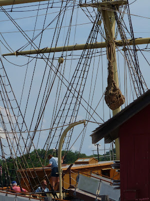
Next we wandered over to the Baltimore Clipper, the Amistad. The photo below is not canted at an angle; the two masts are actually tilted backwards which allowed the clipper to sail much faster than other ships of the day. Baltimore Clippers were used by Americans in the War of 1812 to capture British ships and after the war they were favored by pirates and those running goods from China due to their speed at sea.
Walking the streets of Mystic Seaport is taking a step back in time. The buildings are historically correct and house blacksmiths, print shops, coopers, schools, apothecaries, churches, sail makers, stables and other businesses you'd see in the 19th century. You can wander in and out of these buildings at will and there will be someone there to answer your questions or explain what the building was used for.
There are a lot of "hands on" activities, especially for children. As you are given your ticket and wrist band at the ticket center, you are also given a map which has the daily activities for the museum listed. You can make a lanyard, build a boat, try your hand as a blacksmith.
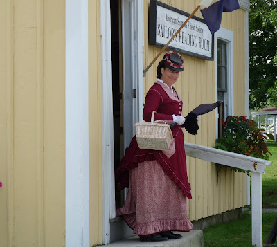
You will find a "witness to history" here; someone playing the role of a person who lived in the mid 1800s and who stays in character as you speak to him/her.
I did find a lighthouse for my collection, albeit a reproduction of the actual Brandt Point lighthouse.
The Mystic River. This area developed into a major shipbuilding area due to the availability of wood, sheltered waterways and flat land. There were two large shipbuilders here where the museum complex is now located and after shipbuilding started to wane other manufacturing businesses developed in their place, keeping the area viable.
As Denny and I were wandering away from the lighthouse we heard the sound of singing and came upon the Joseph Conrad, which was full of people listening to one of the employees talk about life aboard a sailing ship.

Intrigued by the singing and a bit awed at the biceps of the young women heaving a heavy load up the rigging, Denny and I stopped Denise to ask a couple of questions about the songs being sung. Denise explained that the sea shanties were songs sung by the shanty man to develop a rhythm in raising and lowering the sails and hauling loads from the holds, etc. Each shanty man had a huge number of songs in his head and after asking us where we were from, Denise then sang a bit of a shanty that had the Ohio and Mississippi Rivers in its lyrics. To say that Denny and I were impressed is a bit of an understatement! Sea shanties--a fascinating bit of seagoing history and Denise had a lovely voice for singing them.
A cooper (barrel maker) plying his trade. While the clothing may not be historically accurate, the work done here is; even the ship restorers and boat builders here use the old time tools for their work.
In addition to the historical buildings and activities there are special exhibits during the year. Currently there is an exhibit about sailors' tattoos and the tattoo artists and how the craft started. One of the most fun things at this exhibit was a special light that slowly "tattooed" an anchor on your arm as you watched. Computer generated with a buzzing sound in the background you watched as the anchor was inked onto this young lady's arm. Fun stuff!
Of course there are shops to buy things and restaurants on the grounds if you are hungry and park benches where you can sit and watch the river flow by. Most of the buildings are not air conditioned so it was nice to be able to sit for a while in the shade enjoying a bit of a breeze while we people watched.

If you enjoy history and come from a relatively landlocked area like we do, visiting Mystic Seaport is a most enjoyable way to spend a day. Or two.

Enhanced by Zemanta

Saturday, August 20, 2011

Getting Closer

Denny and I are fighting with a troublesome cabinet modification and we have to make yet another trip to the hardware store today. But before we head out, I wanted to update my "States We've Visited" map waaaaaayyyy down at the bottom right corner of this page. See it? Look closely and you'll see that we now have only two (count 'em) white spaces left to fill on that map. And in another month the big guy and I will be starting our fourteenth year of living in the tin can on wheels.

Big wheels keep on turnin'......


Ike & Tina Turner - Proud Mary on MUZU.TV

Friday, August 19, 2011

Cutting You a Break

For the past year or so I've been posting information about the golf courses we've played for any RVers who happen to golf.  I thought it might be helpful for those new to an area and who want to play a golf course that is less expensive than the country club level courses out there.

Realizing that our golfing adventures are of no interest to many (hi, Skippy!), I've decided to start a different blog where I'll be posting our golfing adventures from this point on.  For those who are interested you can find out where we're playing at Two Golfers--One Pension.  Over the next few days I'll be adding the previous golfing posts from this blog and then any new courses we play will be discussed there.

For today; we have a project to work on here in the RV, so my post and pictures of our day trip to Mystic Seaport will have to wait.  Plus I have to work on my post of our golf outing this week.

Catch ya later.

Sunday, August 14, 2011

Wannabees With Wine


This week I received an e-mail from a couple who live in Massachusetts. The e-mail brought up the fact that the couple was interested in Landmark fifth wheels, specifically the Grand Canyon model that we own, and that they are seriously considering selling off everything to become full time RVers. They had been unable to find a Grand Canyon model fifth wheel at any of the local RV dealers and wondered if they could make the hour's drive to our campground to look at The Beast and pick our brains a bit about our lifestyle.

Well! If you know Denny and me (or read my blog at all) you know we are avid proponents of living in a RV full time even if we aren't the staunchest fans of the Heartland RV company. Naturally I wrote back and said "come on down", so yesterday John and Carol made the trek to Rhode Island to see a Grand Canyon up close and personal. And they came bearing wine! Woot! Already they are my kind of people!

What often happens when people want to know about the fulltiming lifestyle is that they start asking questions about how we get mail, pay bills, etc. John and Carol have done their homework by reading some of the hundreds of RVing bloggers online and finding the (now) many web sites dedicated to explaining how to prepare for living in a RV. When Denny and I started researching the idea, there were perhaps two books written about life on the road and "blogs" hadn't hit the scene yet. We discussed letting go of "stuff", storing possessions versus selling them, dealing with ailing parents, traveling with pets. Talking with John and Carol was easy and they felt like friends right from the get go.

We toured The Beast, explaining why we made the changes we've made in the furnishing, modifications we've made to make the unit more liveable for us, the special touches available in the Landmark models. Denny and I didn't touch too heavily on the problems we've had; John and Carol had read some of the information on my web site and they've read many of my blog posts so they have an idea of what we've been through with The Beast. We explained that we seem to be the exception rather than the rule for the most part when it comes to having problems with Heartland products (see? I can be good!) Then we talked and talked and talked until Carol had to call "time out" since she had to work that evening and she hadn't yet been to bed since getting off work in the morning before driving out to see us. Whew! That was a sentence and a half!

Denny and I have no doubt that John and Carol will one day be out there on the road in a shiny new Landmark Grand Canyon wearing big grins on their faces. And when that day comes we'll find a way to catch up with them with a big bottle of wine to toast their new life! So until then, you two-- happy trails!

Saturday, August 13, 2011

A Fort-uitous Trip

Okay, so it wasn't fortuitous, it was planned. But a day trip to Newport to explore Fort Adams and a little bit of Newport on Friday was fortuitous in the sense that we had a lovely sunny day of low humidity to do our wandering.

Set at the tip of a peninsula, Fort Adams State Park is a gem of an area. You not only have the fort to explore (guided tours only at this time), there is a yachting museum, the marina area, a beach, a picnic area and beautiful views whichever way you turn. Denny and I took the hour and a half long tour guided by Bill, who had a rather distracting vocal and physical resemblance to Gilbert Gottfried, but who was extremely knowledgeable about the fort itself.Construction of Fort Adams was begun in 1825 but it wasn't fully completed for another 30 years. Built as the largest coastal fort in the U.S., constructed with walls of granite and shale to repel cannon balls, built with special defenses for attack by land and sea, the fort never came under attack. But the story of the time and effort and type of defenses built into the fort, including the spooky "listening tunnels" was fascinating. A lot of the area is fenced off due to ongoing restoration but the goal of the state is to open the fort to the public without the need of tour guides to control access to the more dangerous sections of the fort.
We were allowed up on the top tier of one section to view the coastline that the fort was built to protect.

Of course there was a strange juxtaposition of the old and the new when some of the view was this cruise ship docked for the day at Narragansett Bay.Strangely enough, even though you can't enter the park without a tour guide, you can rent the park for parties and functions, such as the Special Forces military families' party that was being set up while we were touring.There was a ton of information packed into that hour and a half and a good amount of walking in the hot sun so at the end of the tour Denny and I were ready to find a shady spot in the park to eat our picnic lunch. It happened to overlook the harbor and we watched people take lessons in how to operate tiny sailboats as we ate.Once we finished our lunch we took the driving loop of Ocean Blvd., passing many huge mansions, most of which were hidden behind clever landscaping. There are about five mansions that you can tour but we chose to simply do a "drive by" this time around.

Along Ocean Blvd. we did pass at least two sections of state park where you could park your car and cross the street to climb down the boulders to the ocean. It's not an area for swimming but rather exploring tidal pools and simply enjoying the view and the sunshine which many people were doing. The town of Newport itself was jammed with tourists wandering the historic homes which now house businesses and the mansions that are open to the public were doing a good business also. We had to be really careful on the narrow streets with our very large truck and the rather oblivious tourists who crossed the streets wherever they could. Denny was glad to finally cross the two bridges that led us out of town.
If you love to browse shops, this town is for you. And for those of us who would rather take in a scenic view, they have that too. Win/win.
Enhanced by Zemanta

Friday, August 12, 2011

A Find at Foster Country Club

There are two golf courses within five miles of our campground; the nine-hole Coventry Pines Golf Club and the regulation 18 hole Foster Country Club. Given our druthers, we'd druther play an eighteen hole course any day for the variety.

Located in Foster, Rhode Island Foster Country Club is set among tall trees and gently sloping landscape. This is a walkable course although you would get a workout doing so. There are three sets of tees; blue, white and green. Your scorecard gives two slope/ratings for the white tees and two for the short green tees; one for men and one for women. From the blue tees, your yardage is 6221 yards with a rating/slope of 70.7/116. From the white (men's) the yardage is 5754 yards and 68.8/114. The green tee box yardage is 5130 yards and 69.0/114. There are creeks lined with tall, thick weeds throughout the course as well as a couple of ponds. Some of the sand traps have some pretty high lips for more of a challenge in blasting the ball out of the sand. The fairways and greens are very well maintained with the greens being a lot larger than what Denny and I are used to seeing on public golf courses. Some of the rough is a little dry and burned out but it doesn't really come into play that much as that is the rough that is pretty far off to the sides.

Since we are in Rhode Island where space is at a premium I guess I wasn't too surprised to see a graveyard just off the edge of the fairway on one hole. It is literally in the middle of the golf course.But I WAS a bit surprised to see a second cemetery a little later on, this at the edge of the green.
The pace of play was a bit slow here as the course gets a lot of play. Denny and I played for the senior rate of $38 each to play 18 holes with a riding cart. The golf course also offers special value cards that you can purchase online or at the pro shop for free greens fees and discounts at the club's restaurant.

We didn't mind the slow play too much because of the attractive layout of the course and the fact that the landscaper planted a lot of flowers and flowering bushes throughout the golf course. Denny and I were fortunate to have paired up with a couple of men who played this course a lot because there are a couple of holes that dog leg behind hills and we would have had no clue as to where to aim/hit our balls. It is nice to play with someone who can give you a general idea of distance to the hole or where to aim to lay up for the right line to the green. There is one hole on the course that practically doubles around on itself so having that knowledge was very helpful.
All in all, this is a golf course we'd recommend. And it turns out that there is a campground (Ginny-Bs) that is literally right across the road from the golf course and they offer golf scrambles for their campers. How handy is that?

Wednesday, August 10, 2011

A Camping First

These days most campgrounds prefer that you make reservations in advance so I do. They always ask how many adults, how many children, do we have pets? I answer two adults, no children, one cat that I walk on a leash. That way, if the campground owner has a dog they allow to roam free (and there have been some campgrounds like that) the person on the phone can warn me of that. Fine.

We arrived in Rhode Island on Monday at our reserved site and I was handed a map of the campground and a brochure upon check-in. We were directed to our site and after we were all set up and had eaten lunch I settled back to browse the brochure, luxuriating in the air conditioning since it was ninety degrees outside and very, very humid. As a matter of fact, it was a three tee shirt day for Denny--he soaked through two shirts breaking camp in Massachusetts and setting up here. So imagine my surprise when I read rules #3 and 17 (see the brochure below, clicking to enlarge it.)

And yes, we are running our air conditioner and yes, I am walking the cat on a leash. And no, we haven't been kicked out....yet.


Saturday, August 06, 2011

A Long Drive for Lighthouses

Several of our neighbors here in the campground told us we had to go to Provincetown, at the tip of Massachusetts, to people watch. Unfortunately, they were looking at the openly alternative lifestyle of many of the citizens there as a freak show but I wanted to see this historic town and hit a couple of lighthouses on the way.

Taking US 6 and bypass 6A Denny and I headed north. We had to cross over a couple of very tall bridges and saw the Buzzards Bay Railroad Bridge in the distance. This bridge raises up to allow the passage of tall ships down the Cape Cod Canal. I loved the bit of whimsy on the part of the architect. Driving up 6A you get to see all the gray clapboard cottages and houses you could ever hope to see. After a while, I was hoping for a nice colorful painted lady or something along the Italianate line just as a change of pace. Nope, simply more gray clapboard. The homes are all charming and what I have enjoyed about this area is the propensity of the owners to use wildflowers and perennials in wild abandon in their front yards. The brilliant splashes of color make a wonderful contract to the muted towns of the homes' siding. Driving on twisting, narrow two lane roads did not allow for stopping and taking photographs, sadly.

Our first stop was along the Cape Cod beach where we discovered not only the Highland lighthouse but a nine hole golf course that wandered around the grounds of the lighthouse itself.
If you enlarge the photograph below and look closely at the lower left hand corner, you'll see the red flag of the green on this par 3 hole of the Highlands Links Golf Club in North Truro (yep, thought we were in Nova Scotia for a moment!)On the grounds with the lighthouse (which you can tour) is a small museum and an observation deck where you can look out over the ocean. You can't wander the bluff because of the danger of the land falling away; since the lighthouse was built on its ten acres of land many years ago, all but four acres has been lost to erosion. Me, I'd rather wander around than be confined by a 15x15 foot observation deck, but that was not to be.

Hopping back into the truck we continued north to Race Point beach where we decided to have our picnic lunch. The state of Massachusetts has lifeguards along the public beach area, there is a visitor center and one can buy an off road pass to park on the beach (see the upper right side of the picture for the line of RVs parked on the beach) and miles of biking/walking trails. Race Point is actually a part of the Cape Cod National Seashore, so there is a fee to get into the park (except for those who have one of the park passes such as the wonderful Golden Age Pass which has since been renamed to American the Beautiful-Senior Pass.)As you can see, you are literally on the beach here; it is a favorite spot for local fisherman to stay because just off this beach are some of the best fishing on the Cape, per our neighbors who fish commercially here.
The ranger told Denny and me that it would be a two mile walk in the very coarse sand of the beach at high tide (which meant I was sinking well into the wet sand at the tide line with each step) so we opted to drive to Herring Cove Beach where we could climb near the dunes and take a picture of the Race Point Lighthouse in the distance. While there, this three masted schooner (yeah, I SO sound like I know what I'm talking about!) was skimming by in the distance.
By now it was time to see Provincetown since we had a two hour drive to get back home. Provincetown is a huge tourist area and since whale watching tour season had just started as well as all the other activities the town holds on a daily basis it meant that we were unable to find a parking spot for our big, honking truck. I have to be honest here, we are not shoppers or store browsers or people gawkers, thus Provincetown was simply a too crowded tourist area to us. If we had a smaller car and had come during the middle of the week we probably would have found a museum or tow, climbed up the Pilgrim Monument and wandered the beach. Instead, we simply drove through the middle of town and on out. Unable to stop to take a photograph of the Pilgrim Monument in the center of town, I snagged this one from the 'net.The Pilgrim Monument, designed by Willard T. S...Image via Wikipedia

On the way out of the Cape area we did miss the turn for the Nauset Lighthouse, which I regret, but it was time to head home and put our feet up for a while. It was another beautiful day in the neighborhood, and a great day of sightseeing.
Enhanced by Zemanta

Thursday, August 04, 2011

Golfing Among Cranberry Bogs

Denny and I chose this week's golf course after passing by it on our way to shopping in Plymouth, Massachusetts. Lush green fairways dotted with Saturday morning players tempted us to come back, so Tuesday I looked online for tee time specials and spotted some for Wednesday so I booked an eleven-ten tee time and we were set. Southers Marsh Golf Club was a drive of about ten miles from our campground and we arrived way too soon for our tee time but the young lady at the desk allowed us to pay, pick a riding cart, grab our golf bags and head right for the first tee.

The first thing I said to Denny was, "are those cranberry bogs out there?" Sure enough, they were. As always, you can click on any of my photographs to enlarge them for viewing.Our next surprise was that we were on an eighteen hole executive golf course. I was so busy looking for discounted golf fees that I didn't pay attention to Southers Marsh's web site to see that this was not a full length golf course. My bad. So Denny got to practice a lot of short irons here. From the longest tees the yardage is 4111 and from the shortest it's 2907 yards. The course has sand traps and a few hillsides and enough elevation changes to make it interesting. Since there are no ratings/slopes for such a short course (par 61), instead you can look at photos of the cranberry picking process at the golf course here. And yes, this is a close up of the cranberries growing next to one of the greens. As you can see, the cranberries are just starting to ripen and should be ready in plenty of time for Thanksgiving.
Water only comes into play on the first hole and that's not even a problem. What does come into play are the cranberry bogs; you are not allowed to retrieve your balls from either the bogs or the drainage ditches that surround them therefore you may find yourself with several penalties for a lateral hazard and a few lost balls (uh, that would be me!) The pace of play was slow as there were a lot of groups on the course walking since it is a short golf course.

Luckily for us, the humidity had decreased after a passing rain shower the night before so even though we had to wait (and wait) on each hole, it was a beautiful day, the golf course was in fine condition and Denny and I managed to hit some good shots. Afterwards we had a really good lunch at the Chinese Pilgrim restaurant (hey, what kind of name do you expect in Plymouth, Massachusetts?) so we were happy campers.
Enhanced by Zemanta

Wednesday, August 03, 2011

Yet Another Lighthouse

A walk with the cat before 6AM and then Denny and I make a walking loop around the campground after breakfast. Yesterday morning we walked a little farther off the beaten path of the campground and discovered the river-like pond that sits at the rear of the grounds. We had been told we could find egrets and great blue herons and even the ospreys that nest on the nearby cell phone tower but all we saw was this little green frog.The day was going to be another muggy, scorching hot day but the Old Rochester Farmer's Market didn't open until 3PM so I thought maybe a trip to Ned's Point in Mattapoisett might be a tad cooler while we waited.Mattipoisett (supposed from the Wampanoag Indian word for "place of resting") was once a major whaling shipbuilding center and in fact one of the boat builders built the ship Acushnet which I have learned was the ship that Moby Dick author Hermann Melville sailed on. Denny and I didn't explore the town itself, but simply wandered the small park on Ned's Point where the lighthouse is located. The Ned's Point lighthouse is one of the smaller lighthouses in the area, standing only 39 feet tall. Originally built in 1838, the contractor cut corners and used shoddy materials but the little lighthouse was kept going by a staff of dedicated lightkeepers. The history of the lighthouse is interesting to those of us who enjoy the different character and architecture of the various lighthouses that dot the oceans and lakes of the U.S. The small city park itself is well used by the locals and although the "beach" is simply large boulders tumbling down to Buzzards Bay, the water itself is clear and shallow, perfect for wading and cooling your feet on a sultry day. Apparently during the summer months of July and August the lighthouse is opened to the public on Thursdays (and of course we were there on Tuesday.) There are a couple of picnic tables under some small trees, but the locals know to bring lawn chairs to enjoy the view.

The shallow waters are good for kayaking as these two ladies show. The gentleman in the right hand corner is actually lying on his stomach in the water about 30 feet from the rocks. Farther out, sailboats skittered across the bay in the slight breeze and the distant haze made them appear ghostly.
Our last stop was the Farmer's Market which was a disappointment in the size and number of booths as well as a distinct lack of farm produce. However we did manage to snag a couple of tomatoes and some corn to take home and turn them a yummy meal of BLTs and corn on the cob. Add to that Denny's famous cherry-rhubarb pie topped with a bit of French vanilla ice cream and we were in hog heaven.

Not such a bad way to brave the heat.
Enhanced by Zemanta
Related Posts Plugin for WordPress, Blogger...