We are Denny and Linda, the RV Vagabonds, traveling the country in our 2011 Landmark Grand Canyon fifth wheel. After fourteen years on the road we met our goal of playing golf in every state of the Union, so now we're just being footloose and fancy-free until we get the urge to settle down.
Showing posts with label Montana. Show all posts
Saturday, July 10, 2010
Dam, Another One
Truck maintenance was on our minds yesterday; we needed to have the oil changed and to wash Black Beauty to see how deep the scratches were to her finish. The oil was changed successfully in Columbia Falls and we washed away the mud and some of the marks but it's obvious we're going to have to work on the finish of the truck sometime soon.
As we were driving home we noticed the sign for the Hungry Horse Dam and since we're always good for some dam information (!) we decided to head up that way. There is a tiny visitor center with information on the dam and the local area inside, with a friendly young man and woman available to answer questions. The name Hungry Horse, which was given to the town, the dam, a mountain, a lake and a creek, comes from two work horses which got lost during the winter in the early 1900s. Found weak and starving about a month later, they were eventually nursed back to health and so the name stuck.
Located about 4 miles off the main roadway, the Hungry Horse Dam was built for flood control and completed in 1953. Standing 564 feet tall it has the highest morning glory spillway in the world. What is a morning glory spillway? While I can't show it to you in action, in theory it works like this; when the waters of the Hungry Horse reservoir rise to a certain level, they spill over the morning glory opening down into a series of pipes. The action of the swirling water creates a morning glory effect, but basically it works like the action of water going down your kitchen sink drain, swirling in a vortex down below the dam structure.
The morning glory picture above is courtesy of maps.pomocnik.com, it is not mine.
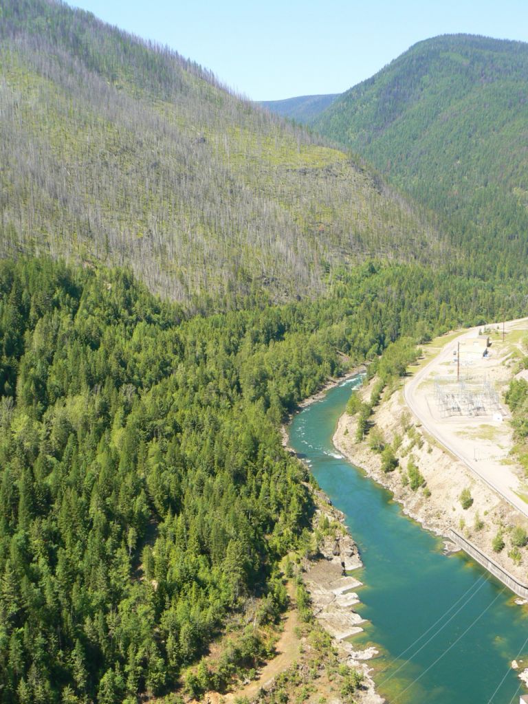
This area too was burned in the forest fires of 2003. Below is the Flathead River coming out of the dam.
And because sometimes I'm five years old.
Friday, July 09, 2010
Never Listen to a Man on an ATV
I'll get to that.
Upon our arrival at our campground on Monday, the lady at the desk suggested several places to visit in the Glacier area one of which was the Polebridge Merchantile. Not because of the history, not because of the scenic beauty, but because of their bakery. Bakery? 'nuff said! So yesterday's jaunt was to Polebridge to buy some huckleberry beer bread for Patty at the desk and whatever scrumptious goodies we could find for ourselves. Understand, we were driving 25 miles one way for food; yep, that's the RV Vagabonds for you!
Imagine our surprise to find the Polebridge Mercantile surrounded by cars and ATVs--apparently the word is out about this place! Located 25 miles from the west entrance to Glacier National Park, 14 of those miles on dirt road, no electricity, the restrooms are outhouses and the pastries are to die for. Along with their breads, they apparently bake a sandwich where the meat, cheeses, onions, etc are placed inside the bread and then baked. Sounds yummy, right? We picked up a bottle of dark cherry cola to wash our huckleberry pear and lemon cheesecake Danishes down and sat on the sawed off logs on the front porch to eat the Danish while it was still warm from the oven. There were several people wandering around the grounds since they rent cabins (and outhouses) and there's also the Northern Lights saloon/restaurant next door that is on the National Register of Historic Places. Built by William Adair in 1904 who later built the false fronted Polebridge Merchantile, the log cabin is an attractive place to sit and rest a while, although they don't open until 4 in the afternoon.
After Denny and I finished our Danish, several men pulled up on ATVs. I asked one of them where the road led that they had come down and he told me they led to Bowman and Kintla Lakes. He said Bowman was nice, but Kintla was a must-see lake. I asked if we could take the truck there without a problem and he said sure--the road got narrow in places but we'd be fine. As the title says, never listen to a man on an ATV. It took us two hours to drive the 16 pot-hole rutted, one lane scary, scratchy bush line roadway. Black Beauty now has Montana pin-striping all down her passenger side which I'm hoping I can buff out eventually and Denny's blood pressure went through the roof each time we couldn't avoid a bone-jarring teeth-clattering front end alignment requiring pot hole. The already blue skies were made bluer by his language, believe me.
After driving for what seemed to be 30 miles, we saw a park ranger by the roadside cutting up a large tree into sections. Denny asked him how far it was to Kintla Lake and he told us another five miles. When Denny said how he was tempted to turn around because the road was so terrible and hard on our truck, the ranger told us that the drive was well worth it (now he was the third person to tell us that because we earlier we had stopped by a road crew and asked how far to the lake and were told at that time it was still 14 miles away, but the drive was worth it) and went on to tell us he had been working there 26 years. His name is Lyle (and I didn't get a picture, darn it!) and at 90 years old, he is the oldest park ranger in Montana. Heck, at 90 years old, I imagine he's the oldest park ranger in the country! Denny volunteered to help him cut the remainder of the tree, but he waved us on telling us he'd be following soon. So we ended up driving the rest of the way--more pot holes, more cussing, more coming off the seat jarring roadway, but we made it. Was it worth it? Yes. I wish we had brought water with us so that we could have taken one of the trails, but it was too hot to walk without water and this is a very primitive area. The road dead ends at the campground/lake area.
Lyle was right behind us all the way (apparently when the park service owns your truck you can drive over potholes with abandon) and came right over to point out the Boundary Mountains and how the snow melts and flows into both Canada and the US as the Canadian border was just behind the mountains across the lake. Lyle is in charge of clearing trees from the roads, filling the potholes with gravel, testing the purity of the water weekly and collecting camping fees and maintaining order within the campground. Kintla Lake is the cleanest lake in Montana and the state bases the quality of their other lakes on that of Kintla Lake. There are no motor boats or trolling motors allowed on the lake, dogs are not allowed to go into the lake (nor on the trails) and the result of that is a lake that is crystal clear and absolutely gorgeous. The lake itself is over 400 feet deep and although the ranger told us how many miles long it is, we forgot the number. I pointed out a submerge log about 100 feet out from shore that appeared to be about ten feet underwater. Lyle told us that the water is 40 feet deep above that log, so we were indeed impressed by the clarity of the water.
Lyle wanted to show me the baby hummers in the hummingbird nest over Kintla Creek, but after watching the mother sit and preen on a branch nearby without approaching the nest we realized that the babies must have flown.
Instead, we stood on the bridge over Kintla Creek and talked until Lyle said he needed to go fix himself some lunch.
Denny and I climbed back into the truck, girding our loins for the long, dusty and bumpy two hour drive back to Polebridge which then would leave us with another 33 miles to get to the campground. About 3 miles out, we were passing a hiker that we had passed on the way in and he seemed to want us to stop, so we did. Now normally we would not pick up a hitchhiker, but this man was obviously hot and tired so we asked how far he needed to go. He only wanted a ride to the Big Prairie area as he was looking for butterflies. Intrigued by his accent, we discovered that Glyron (no idea how to spell his name) is from Hungary and has been traveling for the last two weeks, working his way from Minnesota where he's currently based to several of the national parks before transferring to his new job with the Forest Service to a town not from from Crater Lake in Oregon. The prairie was only about a mile and a half from where we picked him up, but talking to him distracted us from the horrible road. I can only hope that someone picked him up on the way back. Surprisingly, about ten people passed us going towards Kintla Lake as we were leaving (fortunately in the lane and a half areas of the road but still causing the paint scratches to the truck) so he probably had a shot at getting a ride back to the lake since it was about a six mile hike back from where we dropped him.
So was it worth it? Thanks to Lyle and Glyron, it was. Until I look at the truck, that is.
Thursday, July 08, 2010
A Long Day at Glacier
Sensory overload. There's no other way to describe a day of driving the Going to the Sun Road in Glacier National Park. Distracted only by the fact that our probably bigger than 8 foot wide dually truck was driving on lanes that were only seven feet wide in several areas, this park is everything everyone told us it would be and we didn't even attempt to hike any of the trails. Our day was quite long due to construction on Going to the Sun Road as well as by the fact we decided to head up to the Many Glaciers section of the park while we were on the east side of the park. That left us with a very, very long drive home west of the west entrance so we were as Darb used to say "pooped puppies". Very pooped puppies indeed.
Since Bl*gger has limits on photographs I'm uploading some of the day's pix to Webshots. Currently I'm still loading photos since we took another long day trip today which is a whole 'nother story. Tomorrow. Because right now there's a piece of huckleberry/peach pie calling my name. Have to sample the local foods, right?
Monday, July 05, 2010
Natural Fireworks
Sunset comes late here in this part of the world--this was taken about 9:20PM. It had been raining hard and suddenly the sun popped out so I figured I'd better try one last time to get some pictures of a sunset since every evening this week it clouded up and rained near the time the sun was due to set.
Between the facts that I was walking Patches and the mosquitoes were biting the palms of my hands as I was trying to take photographs, I was pleased that any of them turned out at all. The mosquitoes really were bad here; it must have something to do with the herd of cattle and retention ponds nearby.
Hoards of mosquitoes meant the only ones out where those of us walking our pets--most folks stayed inside and missed the sunset.
They missed some pretty skies.
Time for a late night snack. It was not my intent to share.
We're moving on today; we're heading to Hungry Horse, Montana which will be a longish day for us at 300 miles of red line roads. But it should be scenic!
Saturday, July 03, 2010
Almost Over
This has been a weird weather week; sunshine, rain, winds, hail, more rain, more hail, more wind. Hot, cool, cold. Denny and I feel lucky that we snuck in two rounds of golf between the storms and having our power turned off and on and off and on and.....There is still a huge hole around our power pole as the electrician now believes the problem emanates from the electrical circuitry at the office. The workampers are REAL thrilled about that after having to dig down 4 feet at our site. Because these aren't young people, folks.
Between the weather, the electrical problems and the fact that we are out in the middle of nowhere with little to do unless we want to make 100+ mile round trips, I think we'll be pretty glad when this holiday weekend is over with and we can move on. While we won't be a whole lot closer to towns and shopping in Hungry Horse, at least we'll be close to Glacier National Park, which is the whole reason we're heading that way. Everyone who has been there says it is fabulous there, so we're looking forward to exploring the park.
Thursday, July 01, 2010
An Afternoon at Arrowhead Meadows Golf Course
Graced with a break in the storm clouds on Tuesday, Denny and I decided to try the small golf course located on Hwy.89 in White Sulphur Springs, just a hop, skip and jump from our campground. First, however, we had to locate one of the town's two ATM machines, but a lot of places here don't take credit or debit cards, the golf course included. The price for two of us to play 18 holes with a riding cart was $54 total.
Arrowhead Meadows is what I call a farm golf course--it looks like it was created from a farmer's field; flat, wide open, little water, few sand traps, few trees. Which makes it a perfect course for practicing your golf games without having to worry about obstructions and out of bounds. It's a short course, playing at 5894 yards from the men's tees (there's only one) and 5304 yards from the women's tees. The slope/rating for the men's is 67.3/107 and 68.7/114 for the ladies. For the only golf course around for miles, it's in decent shape and at nine holes you can play a really quick round. We finished 18 holes in two hours and we were taking extra shots just to hone our games a bit, simply because there was no one in front of us and no one behind us. Nice. I have to say, we did stop at the turn to beg mosquito spray from the lady at the counter--they were ferocious and I was covered in welts. Between the spray and the fact that the storm started coming in with some good breezes made the second nine much more pleasant to play.
And the scenery isn't bad either.
Monday, June 28, 2010
Another Trip to the Past
Our campground has a mailing address of Garryowen, Montana, however the "town" consists of a gas station/convenience store and the Custer Battlefield Museum. The name of the town comes from the marching song used by the 7th cavalry of George Custer. Originally this was simply a small way station for trains to pick up water and drop of mail and supplies to area forts and homesteaders, but the land was included as part of the Crow Reservation when that was created. Later the Crows sold some of the land to private citizens but still all that was there was the small store. At the time of the 50th anniversary of the battle of the Little Bighorn, workmen were excavating an irrigation ditch when they uncovered a partial skeleton surrounded with buttons and bullets which indicated that the man had been a cavalry soldier. Assumed to be one of the 14 men of Reno's troops who was never accounted for, the remains were reburied in a special monument created to the unknown soldier and concluded with a "burying of the hatchet" ceremony which included burying a hatchet with the soldier after a peace pipe had been smoked.
The museum itself has a very nice display of photographs of American Indians, many of whom were involved in the battle with Custer. There are also Native American artifacts, some bullets taken from areas of the battlefield and information on the battle of Little Bighorn, including a 45 minute documentary film which was extremely interesting and also made you rethink what you learned about the battle in school. That alone was worth the small price of entry.
Between exploring the battlefield area and working on the trailer (putting the repaired leaded glass window back in the door, trying to modify the poorly functioning air conditioning system, defrosting the fridge, etc.) and just sitting outside enjoying the scenery and watching the world go by, the week has passed quickly. It's time to move on, this time to a tiny town called White Sulphur Springs. We'll find someone to remove the stitches from Denny's neck, play a round of golf and see what trouble we can find to get into.
Happy Trails!
Friday, June 25, 2010
Ambivalent About Little Big Horn
I'm not going to retell the story about the Battle at Little Big Horn. It's in all the history books and there is a ton of information online. What I will tell you is that the National Park service has done a fine job here of providing information to help you understand what occurred here on the ridges and plains of the Crow Reservation. There is an audio CD available for purchase, there are a few locations where you can make a call on your cell phone to hear pre-recorded information about the site where you are standing, there are bus tours led by Native American tour guides to take you on the five mile journey to the Reno-Benteen Battlefield where the first skirmish of the Battle of Little Bighorn began, Park Rangers (some of whom are Native Americasn) lead informational walk/talks close to the visitor center or you can simply drive the route, stopping to read the informational plaques placed by the roadside and following paved walking paths. You are asked not to wander upon the grounds, not only in respect for the grave sites but because there are rattlesnakes in the thick grasses. The grounds of the park are as they were on that fatal day of July 25, 1876--when you look to the ridge five miles away where Reno and Benteen waited with their troops, you see it as Custer saw it. Back then the air was filled with dust, gun smoke and screams; today it is eerily quiet.
I have looked forward for a long time to visiting the battle site, but once I was here I was saddened at the suicidal mission of Lt. Col. George Custer and his men. As the park ranger who spoke at the visitor center said, Custer was a hero during the Civil War which ultimately led to the end of slavery but then he was given the task of forcing the Native Americans back to their reservations and thus into a form of slavery. Ironic indeed.
In 2003 the park service dedicated this memorial to the Native Americans who fought on both sides of the battle in an effort to be fair to the Native American perspective. Inside there are panels reflecting statements from several tribe members, creating a circle. On the grounds of the battlefield are red granite markers which show the location of fallen warriors, a practice started only in 1999, once again in an attempt of fairness to the history of the site and the people involved.
I'm glad I came, but what we as a nation did to the Native Americans saddens me. This battlefield is just as much the Native Americans' last stand as it was Custer's.
Tuesday, June 22, 2010
Another New Road
Yesterday's trip from Cody to Garryowen, Montana was another new route for us. This time we took US 14-16 which is the Bighorn Scenic Byway and Wyoming doesn't exaggerate its claims one bit. Abandoned airplanes, red rock, tan rock, white white streams, overflowing rivers, the Big Horn mountains and roads that tried to twist back around on themselves which is not necessarily a fun thing when your twenty-some foot long truck is pulling a 38 foot trailer through said mountains. But gorgeous it was and we even spotted a moose cow on the far side of Shell Canyon before we crested Granite Peak at 9034 feet, which was a climb of 5000 feet for us. Quite a drive indeed.
Friends Don and Vicki were waiting patiently at the campground for us; they had held over an extra day so we could meet up for one day and catch up on their Alaska cruise. Denny and I lost a few hours of time with them because our morning started with Denny having to have a Moh's procedure done to remove some basal cell carcinoma so we left Cody about three hours later than we normally would plus those steep, twisty mountain roads slowed us down quite a bit. But the four of us made the most of what time we had, yakking, enjoying Don's delicious homemade chicken enchiladas and swilling homemade Lynchburg Lemonade. Good times!
Don and Vicki are heading east to get to Ohio in time for our 40th high school reunion while Denny and I are still working our way north and west before we need to be in Seattle for our own Alaska cruise near the end of August. The four of us will meet up again in Myrtle Beach, South Carolina in the fall for a month of talk, golf, games, Happy Hour bar hopping, beach walking, shark teeth searching good times.
In no particular order, leaving Cody, Wyoming, heading east on US 14 through the Big Horn mountains to Interstate 90 up to Garryowen, Montana.
Foothills.
Denny and I thought this was an airplane graveyard. It turns out it is the Museum of Flight and Aerial Firefighting. Kinda.
Driving through the Shell Canyon portion of the trip. There is a waterfall in the canyon, but the parking lot was too crowded for our rig, plus we had miles to go and promises to keep.
More of the canyon.
Every curve in the roadway led to a new palette of colors.
The state of Wyoming does something I think is interesting--they label the various rock formations with the era that it was created along with the tentative dates. I did not take any pictures of any of the signs though.
We had been coming down off the mountains for quite some time before I took this photo since it was so hazy in the distance. We were WAY up there!
After we were all set up and settled in with an adult beverage and chatting with our friends Don and Vicki we were subjected to a brief thunderstorm. When that cleared up we ate dinner outside and then had a nice (not spectacular, but nice) sunset to enjoy.
The clouds above us were pretty neat, though. Vicki and I checked for stars later, but the clouds were still thick in the sky. I would imagine I'll be able to see a lot of them if the clouds clear up this week.
I would say our route is a good one for a day trip as there were a lot of picnic areas and small visitor centers (and that waterfall!) and places to pull over and just enjoy the scenery. The pictures don't begin to do the area justice.
Subscribe to:
Posts (Atom)